


ID :
102689
Tue, 01/26/2010 - 15:25
Auther :
Shortlink :
http://m.oananews.org//node/102689
The shortlink copeid
ANCIENT MAPS FOUND IN EGYPT CONFIRM HISTORICAL TRUTH
Baku 26 January (AzerTAc). To bring to the notice of the world community the right voice of Azerbaijani people fighting now for restoration of territorial integrity of the country, to expose the Armenian propagation built on lie, we need to lead up to everyone the truth about Azerbaijan.
Govhar Bakhshaliyeva, director of the Institute of Oriental Studies of Azerbaijan National Academy of Sciences, MP, professor, has found out in the Egypt`s Dar Al-Kutub Library five historical maps important for Azerbaijan’s history. As informed from the Institute, the maps show that Armenia was too far from its present territory, in the south.
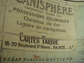
The said library houses a collection of over 15 thousand maps. As stated, one of the maps was published by A. Tarid in the Saint Denis Boulevard early in the past century. The map, prepared to show the railways and navigation lines, covers European and Asian countries. The territory of the state described on the west coasts of the Caspian Sea and presented as Azerbaijan on the map, coincides with the territory of Azerbaijan Democratic Republic (1918-1920). The disputable areas are also presented as Azerbaijan`s territory on this map. The map confirms that Nagorno Karabakh, including Shusha, belong to Azerbaijan and also shows Derbend, Gasimkend and upper territories as Azerbaijan`s territory.
The maps, published in the past centuries in the countries of Europe and Asia and covering various historical stages, proves to be true that the Western scientists and cartographers were well informed on territorial integrity of Azerbaijan, and that Armenia was in the south, which is far from the present territory. All it gives new grounds for exposure of false propagation of insidious Armenians. On the said maps, in the west, the border passes through the Goyce Lake. Mehri, Gafan, Gorus, Sisyan, Vardenis, Krasnoselsk regions of the present Armenia, as well as part of Berd region, are shown as the Azerbaijani territory.
The other map shows Iran`s territory after the well-known Gulustan and Turkmenchay treaties. The map was drawn up in Persian language and toponym of “Azerbaijan” is shown on the territory from the Araz River till borders of modern Iraq. The map shows Ahar, Marand, Savalan Mountain, the Lake of Urmia, cities of Maraga, Mahabad, Maku, Khoy, Ardabil, Miyana, Tebriz and others cities of Azerbaijan.
The third map was drawn up in 1785 in Venice. The map, named as “Empire of Alexander the Great”, covers Europe, Africa and Asia. The map was drawn up by Italian Antonio Zatta and his sons. Here, Albania is shown in the western coast of Caspian. The Araz River locates in the south. On the map, Armenia is shown not as a state, but only as a geographic territory in very south of the Araz River, in neighborhood with Assyria and Mesopotamia.
The next two maps were drawn up in Amsterdam, the Netherlands, during the Ottoman Emperor Mehmet III (1595-1603). Another map was drawn up and printed by the artist Friedrich de Wit in 1775. The maps show Armenian territories far from their present location in the south and having no relation to the territory of modern Armenia. The map of Friedrich De Wit also shows the toponym of Shirvan in the territory of Azerbaijan.
Apparently, all these maps, confirming territorial integrity of Azerbaijan and exposing the Armenian fabrications, completely prove that during the past centuries it was unconditionally accepted by the scientists in the West and the East, and they show that historical Armenian territories have no relation not only to Nagorno Karabakh, but also to the present Armenian state.
Govhar Bakhshaliyeva, director of the Institute of Oriental Studies of Azerbaijan National Academy of Sciences, MP, professor, has found out in the Egypt`s Dar Al-Kutub Library five historical maps important for Azerbaijan’s history. As informed from the Institute, the maps show that Armenia was too far from its present territory, in the south.
The said library houses a collection of over 15 thousand maps. As stated, one of the maps was published by A. Tarid in the Saint Denis Boulevard early in the past century. The map, prepared to show the railways and navigation lines, covers European and Asian countries. The territory of the state described on the west coasts of the Caspian Sea and presented as Azerbaijan on the map, coincides with the territory of Azerbaijan Democratic Republic (1918-1920). The disputable areas are also presented as Azerbaijan`s territory on this map. The map confirms that Nagorno Karabakh, including Shusha, belong to Azerbaijan and also shows Derbend, Gasimkend and upper territories as Azerbaijan`s territory.
The maps, published in the past centuries in the countries of Europe and Asia and covering various historical stages, proves to be true that the Western scientists and cartographers were well informed on territorial integrity of Azerbaijan, and that Armenia was in the south, which is far from the present territory. All it gives new grounds for exposure of false propagation of insidious Armenians. On the said maps, in the west, the border passes through the Goyce Lake. Mehri, Gafan, Gorus, Sisyan, Vardenis, Krasnoselsk regions of the present Armenia, as well as part of Berd region, are shown as the Azerbaijani territory.
The other map shows Iran`s territory after the well-known Gulustan and Turkmenchay treaties. The map was drawn up in Persian language and toponym of “Azerbaijan” is shown on the territory from the Araz River till borders of modern Iraq. The map shows Ahar, Marand, Savalan Mountain, the Lake of Urmia, cities of Maraga, Mahabad, Maku, Khoy, Ardabil, Miyana, Tebriz and others cities of Azerbaijan.
The third map was drawn up in 1785 in Venice. The map, named as “Empire of Alexander the Great”, covers Europe, Africa and Asia. The map was drawn up by Italian Antonio Zatta and his sons. Here, Albania is shown in the western coast of Caspian. The Araz River locates in the south. On the map, Armenia is shown not as a state, but only as a geographic territory in very south of the Araz River, in neighborhood with Assyria and Mesopotamia.
The next two maps were drawn up in Amsterdam, the Netherlands, during the Ottoman Emperor Mehmet III (1595-1603). Another map was drawn up and printed by the artist Friedrich de Wit in 1775. The maps show Armenian territories far from their present location in the south and having no relation to the territory of modern Armenia. The map of Friedrich De Wit also shows the toponym of Shirvan in the territory of Azerbaijan.
Apparently, all these maps, confirming territorial integrity of Azerbaijan and exposing the Armenian fabrications, completely prove that during the past centuries it was unconditionally accepted by the scientists in the West and the East, and they show that historical Armenian territories have no relation not only to Nagorno Karabakh, but also to the present Armenian state.